


This year, in correspondence with our city’s 185th anniversary, we were proud to come together with several of our fellow community organizations to celebrate all the great things that make St. Charles a treasure trove of history.
Former home of Judge William D. Barry, Kane County Judge, President of the Kane County Bar Association, Campaign Manager for Rep. Col. John Farnsworth, and friend to Abraham Lincoln.
Adopt an Artifact! is a unique program offered by the St. Charles History Museum that allows people to “adopt” various artifacts from the Museum’s Collection. Artifacts may be adopted for up to a year and can be renewed.
For those of us who call St. Charles home, we can learn from the people who settled here before us and their stories; their strengths, dreams, decisions and accomplishments, sprinkled with their struggles and disappointments. Consider that someday, we will be part of a future story with our own legacies.
Researching the Underground Railroad can be incredibly frustrating at times, as we often run into dead ends due to the scarcity and secrecy of sources. The abolitionist movement was a dangerous cause to stand with, especially to those that were actively helping escaped slaves. Leaving behind evidence of abolitionist activity could have been deadly back then, and now makes research and finding the cold hard truth difficult.
For the third year in a row, we temporarily closed our doors to the public in order to complete important projects around the Museum. Over the four weeks, we had nearly 30 helpful volunteers contribute their efforts. While there are still projects to be finished, January 2019 Shutdown was a complete success!
The area of Langum Woods, near the east bank of the Fox River, has had a few names in the past few centuries: 55 Acres, Camp Kane, and now Langum Park. The area has quite a rich history, dating back to the Civil War. The southern end of Langum Park is dedicated with a memorial for Camp Kane. When I read about Camp Kane, I started to wonder where exactly camp Kane was located. I started researching the area to see what the area of St. Charles looked like in the 1860s and what remains of those buildings today.
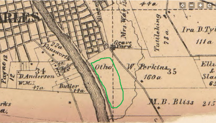
1860's Map of St. Charles showing location of Camp Kane highlighted in Green
Camp Kane was located in and near Langum Woods but the exact location is unclear without evidence. The following information along with reference to a map of St. Charles from the 1860’s helps achieve a better understanding of where the camp was located. I started off searching the internet for what I could find about Camp Kane. I quickly learned that the camp was located on land that Col. John Farnsworth had owned on the east bank of the Fox River. The land sat between the Fox River and 7th avenue. The St. Charles Library website also mentioned that the camp is in the location of today’s Langum Park. I then went to the museum’s primary sources to see if I could confirm and narrow down the location of the camp. In reading various primary documents about Camp Kane, such as books, brochures, letters, and journals, I further strengthened the beliefs of the location that my previous sources had stated.
From reading a statement in a book about the history of the Illinois 8th Cavalry Regiment, which was stationed at Camp Kane, I concluded that the camp must have been north of the Farnsworth mansion because when the regiment marched south to Geneva it was necessary for them to pass opposite of Col. Farnsworth’s mansion. Although the Farnsworth mansion no longer stands today, as it was torn down in late 1992, the location of the mansion was on the west side of the river on top of the hill overlooking where the Mount St. Mary’s park is today. I thought I knew a potential location for the camp until I read these next few sentences from the Camp Kane dedication brochure from 1982
“McCauley’s stone quarry bordered the property on the north; on the far east as the South Cemetery (7th Avenue Cemetery) where Evan Shelby and other early pioneers are buried. In between was a large stand of timber known for years by local residents as “55 Acres,” and now known as Langum Park. The clearing was along the east bank of the Fox River”
I knew where the South Cemetery was and the Fox River, but I didn’t know the location of the McCauley’s quarry. My next step was to uncover the location of the quarry. I soon came across a history of the McCauley family of St. Charles. The author, Ken McCandless believed he had found the location of the quarry at the junction of 5th and Riverside Avenue, and at first, I also believed this was the location of the quarry.
After hours of sorting through the museum's photographs and primary documents, I became stuck with no idea what to search for next. Perhaps this meant I was done with my long and difficult journey locating Camp Kane. I reflected on my research journey and began to realize many of the sources I read were 2nd hand accounts. I wasn’t reading the evidence, I was reading about the evidence. In search of this original evidence, I went to the Kane County Government buildings to discover more. While I was there I looked at old maps, aerial maps, and deeds from the late 1800s. I found evidence that contradicted and proved my original ideas wrong.

One of the most surprising things I learned was one that contradicted what many people had written about Camp Kane and Col. Farnsworth. Many people believed that the camp was set up on land that Farnsworth had bought in 1858. There is no record of Farnsworth owning land on the east side of the Fox River. The deed that I found for Farnsworth buying property in 1858 was for land on the west side of the river where the mansion was later built. The land that people assumed was owned by Farnsworth, was actually owned by a farmer named Ortho W. Perkins. Colonel Farnsworth was a well-respected man and most likely asked Perkins to use the land for the Civil War and Perkins agreed. This could be a reason for why there is no record of a land transaction. I even remembered a quote I read which mentioned the soldiers being camped on a part of the Perkins farm. Before seeing the evidence I had quickly overlooked that statement.
When looking at some maps from the mid-1900s, there was a land feature that caught my eye. In the area of Langum Park where the baseball fields are now, was a landfill area. If there was an area to discard unneeded tailings and dirt, it is quite likely that this was the area of the quarry. I viewed an aerial photo from 1939 which showed an area which looks like a stone pit on the northeast corner of Langum Park. This seems like a much more likely location for the quarry than the area Ken McCandless said the quarry was. The block between 5th Ave and Riverside Ave is much too small to be a quarry.

This photo is most likely McCauley’s quarry. It is an image of a quarry in St. Charles from the late 1800s and it is unlikely there was more than one quary inSt. Charles at that time.
At this time, I rethought my theory about Camp Kane being located north of Colonel Farnsworth’s mansion. The soldiers passed his house when they marched south to Geneva. I know before the regiment left there was a ceremony to show them off. This ceremony most likely took place in town. From town they would have marched south, past Col. Farnsworth’s mansion and continued on to Geneva.
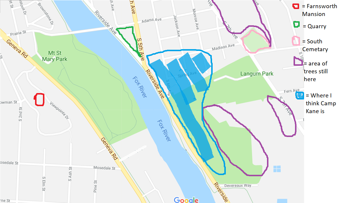
With all these facts in mind, I created a new map showing my new thoughts on the location of Camp Kane.

Langum Park is no longer the 55 acres it used to be. The park is now a total of 31.2 acres. The park area has increased since Mayor Langum set aside the 20 acres of land 98 years ago. The forested area of the park has shrunk to about 9 acres. Today the park has baseball fields, tennis courts and a playground. There are plenty of picnic tables throughout the park and a great view of the Fox River. In the winter there is a sledding hill and an ice rink for hockey. On the south end of the park stands the Jones Law Office along with multiple signs about the Civil War and Camp Kane. Civil war reenactors have come to Langum Park multiple times throughout the last few years.
Langum Park was named for one of St. Charles longest serving Mayors, Doctor I. G. Langum. Mayor Langum set aside 20 acres of land in 1925 to become a public space. He was a very productive mayor and St. Charles benefited from his good deeds as mayor. He was the Mayor for seven consecutive terms. He started a soup kitchen during the Great Depression and many other projects to help the community during the difficult time.
With the summer season here, many parents have had to make the decision of what to do with their children. In the past, many parents looked to Miss Pike’s Progressive Camp in the Fox River Valley to keep their children active and entertained during the summer months.
Miss Pike’s Progressive Camp began in the 1930s and was located at Pinelands on Route 25, north of where Little Woods School is today. The camp was directed by Dorcas and Stella Marie Pike, both graduates of the Pestalozzi-Froebel Teachers College on Chicago. Charles Pike, the brother of Docas and Stella also worked at the camp, serving as athletic supervisor for the boys’ sports and golf lessons. In addition, the camp had many counselors to offer guidance and give special attention to the needs of the campers.
Enrollment in Miss Pike’s Progressive Summer Camp typically lasted eight weeks and was available to boys and girls ages three to fifteen. The camp focused on developing the physical and social health of each individual child with activities such as horseback riding, tennis, golf, twice daily swimming lessons, hayrack parties, picnics, nature excursions, and after dinner movies. Private tutoring was also available to students for an additional charge. To ensure the healthy development of campers, the Pikes kept daily records of camper’s weight and hired a University of Chicago clinic specialist to supervise their diets.
The Pikes also worked to strike a balance between relaxation and outdoor actives within their camp. They placed all the campers on a regular sleeping schedule which included naps for the younger campers. Finally, the Pikes ensured that the children were surrounded with experienced councilors who provided supervision and friendship for the campers.
The regular summer season for Miss Pike’s Progressive Camp ran from June 20 to August 16 and cost $240 per camper, but a $40 discount was offered if a camper was registered by the first of May. However, when the summer camp ended in may many parents wished that their children could remain at Pinelands and continue their educations.
In 1932, aware of the demand Stella Pike and her husband bought a large house at the southeast corner of Main and Seventh Streets in St. Charles and opened the Miss Pikes’ Progressive School. The combined boarding and day school offered instruction for boys and girls in the elementary grades but soon began to offer high school level courses. Overall, the Pike’s strove to incorporate an academic curriculum with a hoke-like familiar atmosphere so children would become polite, well-rounded individuals.
Each year the school would open the second week of September and closed around the first of June. Tuition was approximately $950 and included everything but piano and voice lessons. As more students entered the school, the Pikes felt the need for more space and decide to build an addition to their house in the late 1940s. The school continued at this location up until the late 1960s when Stella and her husband retired. At the time of the closure, the school was nationally renowned and had housed children from across the country.
Archie Bentz was the last owner of what is now the St. Charles History Museum and over the last few year's he has been compiling a list of the Tri-Cities service stations. When the Museum was creating its new exhibit Serving Gas to Preserving History, Archie was a wealth of information but it also sparked some new questions and we are looking to the community for help.

This is a current Google Earth photo of 311-313 N 5th Street in St Charles, the present home of Boyle Body Shop.
I am currently working on compiling a history of Tri-City service stations and automobile dealerships. I have a limited history of this site going back to 1932 as shown below and would appreciate any information to fill in the gaps in dates and names of those in operation.
Here is what I remember of this area in St. Charles as a kid; The main north-south highway that we know of today as Route 31 or Second Street in St Charles did not pass under the railroad tracks about 3 blocks north of Rt 64. There had been no provision for a tunnel or underpass of the railroad right-of-way. I believe there only two ways to go north of St Charles on the west side; 1) travel west on Dean Street and drive over the tracks, 2) there was a tunnel under the tracks either on north 5th or north 6th. I believe that since there was this early filling station on north 5th it would stand to reason it was constructed to service the northbound traffic leaving town.
The original filling station would have been the right side of the building prior to the addition of service bays.
313 North 5th Street History
Who remembers when north 2nd Street and the railroad underpass were constructed and the highway was designated Route 31?
Does anyone have early photos of this location that could be shared with the Museum and myself?
*Special tours may be scheduled ahead of time for any day of the week, including Monday
Your City. Your History. Your Sense of Community.


The Museum welcomes participation in all activities by individuals with disabilities and special needs by working cooperatively with the Fox Valley Special Recreation Association. The Museum is committed to inclusion by providing public programs in the most integrated setting, providing to the maximum extent feasible for interaction between people with and without disabilities.If you or a household member has a special need or request for reasonable accommodation in accordance with the Americans With Disabilities Act, please contact us at least one week in advance of an activity, program, or visit date. For more details, call 630-584-6967.


